AirBurr Maps by Collisions
 Mar-03-13
The AirBurr UAV navigates by crashing into things to gradually build a map of its environment.
Mar-03-13
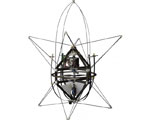
The AirBurr UAV navigates by crashing into things to gradually build a map of its environment.Developed by researchers at Switzerland’s EPFL Laboratory of Intelligent Systems, the AirBurr is in its 11th version. Like earlier versions, the UAV protects its rotor blades and delicate electronics within a flexible carbon fiber frame, and can right itself after falls by extending a set of retractable carbon fiber legs from its sides. The new version differs, however, in its ability analyze the force and position of the collisions and use the information create a map of its surroundings.
The AirBurr could have applications in exploring dark or cramped spaces, such as caves or disaster sites.
More Info about this Invention:
[IEEE.ORG][LIF]
Add Your Comment