Mapping Quadcopters Search without GPS
 Nov-05-18
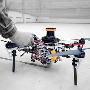
A fleet of autonomous drones able to move through thick forests without GPS could offer a new way to search for lost hikers.
Nov-05-18
A fleet of autonomous drones able to move through thick forests without GPS could offer a new way to search for lost hikers.The system was developed by a team from MIT and NASA to provide autonomous drones with the ability to navigate areas where GPS is unreliable. To that end, the LiDAR-equipped quadcopters were outfitted with onboard software that allows the drones to create detailed maps of their environment as they discern patterns and recognize where they have already been. The data is displayed as a 3D map that can be accessed at a base station and used to ensure all areas are explored.
More Info about this Invention:
[DIGITALTRENDS.COM][NEWS.MIT.EDU]
Add Comment
Are there backup systems for GPS, which is vulnerable to solar storms and attacks? Automates may need both electrical maps and beacons to navigate.
Posted by Uolevi Kattun on November 6, 2018
fields are required.
Comments
Are there backup systems for GPS, which is vulnerable to solar storms and attacks? Automates may need both electrical maps and beacons to navigate.
Posted by Uolevi Kattun on November 6, 2018
Add your Comment:
[LOGIN FIRST] if you're already a member.fields are required.
Show 1 Comment