Integrated Automation System with Picture Compilation System
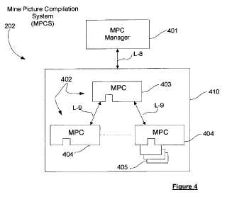
Methods and systems are described for generating a data representation of a geographical region as an adjunct to conducting autonomous operations within the region. The method comprises receiving information specifying a plurality of localised zones having operation-defined geographical boundaries within the region; receiving heterogeneous data descriptive of the region; associating the received data with respective localised zones; fusing the received data associated with the localised zones into data representations of the localised zones; and integrating the data representations of the localised zones into a common data representation of the geographical region.Attached files:
Patents:
WO 2,010,124,339
Inventor(s): NETTLETON ERIC [AU]; HENNESSY ROSS [AU]; DURRANT-WHYTE HUGH [AU]; GOEKTOGAN ALI HAYDAR [AU]; HATHERLY PETER JAMES [AU]; RAMOS FA
Type of Offer: Sale
« More Engineering - Geographical Patents