Technology Wanted:
Tool to Determine Cover Thickness above Bedrock in Northern Chile
Status: Completed
Deadline for Submissions: May-18-2015
Award:
1) $3,750 referral fee for each accepted "Proven Tool" lead.
2) $2,500 referral fee for each accepted "Tool That Can be Adapted" lead.
3) $1,250 referral fee for each accepted "Proof of Concept" lead.
An accepted lead is a lead that the client decides to follow up on.
The seeker wishes to obtain a high confidence, non-invasive, low cost tool capable of determining the thickness of the cover, without having to drill, interfere or alter the landscape in any way.
Background: The cover, geological units that exist above the bedrock, varies in its thickness along Northern Chile. Knowing the exact thickness with high confidence in extensive covered areas (such as pampas), permits more accurate planning for mineral exploration missions.
Below the cover (bedrock) there are intrusive rocks, volcanic and sedimentary units. The cover is mainly composed of gravels and caliche layers ("salty-crust" rich in nitrates and phosphates) interbedded with thin ignimbrites layers (old volcanic ash consolidated deposits).
Categories of expected deliverables:
Criteria: The tool MUST:
Deadline for Submissions: May-18-2015
Award:
1) $3,750 referral fee for each accepted "Proven Tool" lead.
2) $2,500 referral fee for each accepted "Tool That Can be Adapted" lead.
3) $1,250 referral fee for each accepted "Proof of Concept" lead.
An accepted lead is a lead that the client decides to follow up on.
The seeker wishes to obtain a high confidence, non-invasive, low cost tool capable of determining the thickness of the cover, without having to drill, interfere or alter the landscape in any way.
Background: The cover, geological units that exist above the bedrock, varies in its thickness along Northern Chile. Knowing the exact thickness with high confidence in extensive covered areas (such as pampas), permits more accurate planning for mineral exploration missions.
Below the cover (bedrock) there are intrusive rocks, volcanic and sedimentary units. The cover is mainly composed of gravels and caliche layers ("salty-crust" rich in nitrates and phosphates) interbedded with thin ignimbrites layers (old volcanic ash consolidated deposits).
Categories of expected deliverables:
- Proven tool in Northern Chile: This is a tool already validated for the specific intended application and can be readily implemented in the field.
- Tool that can be adapted for the desired application in Northern Chile: This is a tool that has been rigorously proven or is being used in an adjacent area of technology, and can be adapted to meet the requirements of the specific application.
- Proof of concept that can be applied in Northern Chile: This is a tool that has initial proof-of-concept results, data, and prototypes. It demonstrates potential applicability of the concept to meet the requirements of the specific application.
Criteria: The tool MUST:
- Provide accurate results with an error margin of no more than ±5%
- Provide reproducible results with an error margin of no more than ±10%
- Not be affected by the presence of groundwater (which is common) nor caliche
- Estimate the cover thickness down to 1000 meters without having to drill, interfere or alter the landscape in any way
- Measure regardless of the composition of the Cover
- Quick method to provide a short stay in each point (not more than a few hours)
- Deliver results in a time wise manner (Not more than a couple of days between data acquisition and delivery of the information)
- Be safe for the environment and communities: Does not produce any contamination or by products (acoustic, gas, liquids, etc.)
- Easy to transport to the field (equipment should fit in the back of 2 pick-ups at the most)
- Easy to operate (Power requirement: No need to connect to the central grid. Operators required: No more than 6 people)
- Logistically light (Pass from an area to the next one in short time setting, mobilization, demobilization-not more than a couple of days)
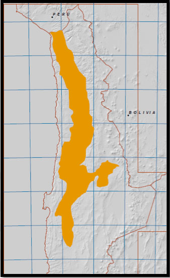 Figure 1. Map of the North of Chile 1:1.000.000. The map shows the covered area of interest found in the central depression of the Atacama Desert. |
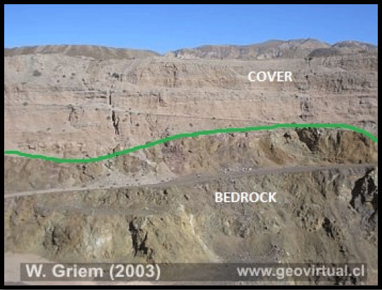 Figure 2. Cover and Bedrock in the North of Chile A section showing the Cover and the Bedrock as seen in the Atacama Desert (W. Griem). |