MapLite System Lets Self-Driving Cars Explore Rural Roads
 May-07-18
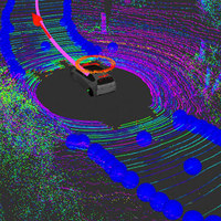
The MapLite system from MIT would let self-driving cars take the path less traveled.
May-07-18
The MapLite system from MIT would let self-driving cars take the path less traveled.Currently, most self-driving car systems rely on well-mapped roads, with lane markings and clear signs—something rural roads can lack. To overcome this limitation, the team from MIT created the MapLite system, which replaces digital maps with sensors and only ‘rough estimate’ GPS data. After the final destination has set, the system creates a ‘local navigation goal’ based on the visible road ahead. The car’s LiDAR system then guides the vehicle to each consecutive goal, while also keeping the car within the boundaries of the road.

More Info about this Invention:
[FORBES.COM][THEDRIVE.COM]
Add Comment
Can this benefit also the newest supportive wheelchairs?
Posted by Uolevi Kattun on May 8, 2018
fields are required.
Comments
Can this benefit also the newest supportive wheelchairs?
Posted by Uolevi Kattun on May 8, 2018
Add your Comment:
[LOGIN FIRST] if you're already a member.fields are required.
Show 1 Comment