3D-Printed Braille Maps
 Feb-27-16
Using a 3D printer, researchers have created durable, 3D maps that could make it easier for blind individuals to navigate their surroundings.
Feb-27-16
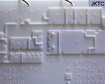
Using a 3D printer, researchers have created durable, 3D maps that could make it easier for blind individuals to navigate their surroundings.The maps were created by a undergraduate and his professor at Rutgers University, and are designed for use at the Joseph Kohn Training Center for the visually impaired in New Brunswick. Made using a 3D printer and CAD software—which offers a quick map-printing option—the 3D tactile maps are made up of layers printed on a flat sheet, which eventually pile high enough to become three dimensional. The maps are also small enough to fit in a binder, which means they can be carried around by the student, and include a Braille legend to help student better understand the map.
More Info about this Invention:
[MEDGADGET.COM][NEWS.RUTGERS.EDU]
Add Your Comment